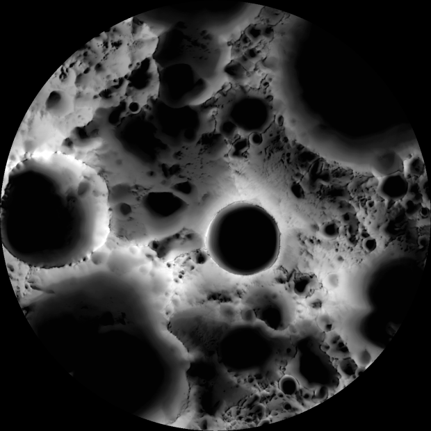
It’s an “illumination map” of the Moon’s south polar region, made from some 1,700 photographs taken by the Lunar Reconaissance Orbiter Camera over a period of six months (which�think about it�is six lunar days). Since the Moon’s axis is tilted a mere 1.54 degrees (compared to the Earth’s rakish 23.5-degree tilt), some regions near the poles are perpetually shrouded in shadow while others remain lit most of the year.
The image is made from photographs by a painstaking process, as described at the LROC web site:
In a six month (six lunar days) period, the LROC Wide Angle Camera (WAC) collected 1,700 images of the South Pole covering the same area. Each image was map projected and converted to a binary image (if the ground was illuminated that pixel was set to one, and if shadowed zero) to differentiate between sunlit and shadowed regions. All the binary images were then stacked, and then for each pixel it was determined what percentage of the time during six months that spot was illuminated. Presto – an illumination map!
The abyssal socket near the center is called the Shackleton Crater. Named after the famed polar explorer, it’s 19 km wide and 4 km deep. The lunar South Pole is to its left at nine o’clock.
With indications of temperature differences, optimal locations for imaging equipment, and possible sites of frozen water, the map will be used to plan robotic and manned missions to the Moon.
[via New Scientist‘s Short Sharp Science] Gearfuse Technology, Science, Culture & More


